In the late 19th century, economic development of the Mother Lode
depended on it being linked via railway to the commercial
networks of the western United States. Calaveras was served by
three railroads: the Stockton and Copperopolis, the San Joaquin
and Sierra Nevada, and the Sierra Railway.
During the Gold Rush, the area in today’s West Calaveras south of
the Mokelumne River claimed towns called Poverty Bar, Clay’s Bar,
Winters Bar and Limerick, the latter after the many Irish
immigrants who settled there. In the mid-1860s, as camps and
settlements dwindled, pioneers who hailed from Iowa named their
most significant town Camanche, after the Iowa town of the same
name–and misspelled the name of the Native American tribe
(Comanche) in the same way.
The community of Campo Seco (Spanish for dry field or camp) was
an early placer mining camp that also provided services to the
bars along the Mokelumne River (recorded as State Historic
Landmark No. 257). The camp was located on Oregon Gulch, which
enters into the Mokelumne River at Oregon Bar, and served many of
the miners who mined along the numerous bars of the Mokelumne
River.
When gold was discovered in California in 1848 it was an undeveloped region without the infrastructure to feed, clothe, supply or house the thousands of people who were arriving daily. Many of the gold seekers and most of the supplies came through the new city of San Francisco, which at that time was a city of tents. Entrepreneurs saw that the need for housing could be met with prefabricated houses from China. During the first few years of the gold rush between 75 and 100 of these Chinese houses were brought to California.
The land that now encompasses Arnold was first taken up by the Willis Dunbar family of Murphys, who had an 880-acre ranch that provided meat, vegetables, timothy hay, potatoes, and fruit (primarily apples) to nearby resorts and lower elevations from the late nineteenth century into the twentieth. The Dunbars also had a sawmill, which supplied their lumberyard in Murphys, and extensive lumber operations in the area (Elliott 1885:96-97; Mace 1993:145).
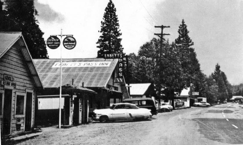
It was the advent of the automobile, however, that led to the development of Arnold, as more and more families took to the mountains to partake of the clean rivers, lakes, and cool forests. Commercial establishments were developed along the Ebbetts Pass route to serve travelers and tourists alike, providing automobile services, sustenance, and lodging. Arnold was founded on one of these establishments, and received its name from Bob and Bernice Arnold, who began operating a bar, restaurant, and three cabins there in the 1930s. This business became the nucleus for several other commercial enterprises, all catering to the traveler.
The major growth in Arnold, however, developed after the construction of the Blagen mill, built in White Pines in 1939. A modern twentieth century operation, the enterprise was first a family business. The Blagens established a company town, named White Pines, near their mill on what is now White Pines Lake. The company ran two shifts of men, producing a great amount of lumber during World War II, and employed more than one hundred men. During this period the mill was taken over by American Forest Products, but kept the Blagen name. The mill flourished, but then waned in production, leading to its closure in 1962 (Davis 1993:7-8).
Today, due in part to its proximity to the Calaveras Big Trees and the Mt. Reba ski area, Arnold is one of the county’s fastest growing communities and is being developed primarily as an area for second homes and full-time residents.
Refrences
Costello, Julia G., editor. 1988 Historical and Archaeological Research at the Calaveras Big Tree Cottage Area. Report prepared for Calaveras Big Trees Association and California Department of Parks and Recreation.
Davis, David H. 1993 Early Logging in the Sierras, with Special Reference to the Forested Valleys of Calaveras County. Heritage Resource Program, Calaveras Ranger District, Stanislaus National Forest.
Elliott, W. W. 1885 Calaveras County Illustrated and Described. Bicentennial Reprint, 1976, by Valley Publishers, Fresno.
Gudde, Erwin G. 1975 California Gold Camps. University of California Press, Berkeley
Koeppel, Elliot H. 1995 The California Gold Country: Highway 49 Revisited. Malakoff & Co. Publishing.
Mace, O. Henry . 1993 Between the Rivers, A History of Early Calaveras County, California. Cenotto Publications, Jackson, California.
Office of Historic Preservation. 1998 The California Register of Historical Resources, Public Resources Code, Chapter 11.5, implemented January 1, 1998.
Psota, Sunshine, and Judith Marvin. 2001 Historic Resource Evaluation Report of Three Roads Along State Highway 4 Between Camp Connell and Ganns, Calaveras County, California. Anthropological Studies Center, Sonoma State University Academic Foundation.
Storer, Tracy I. and Robert L. Usinger. 1963 Sierra Nevada Natural History. University of California Press, Berkeley.
Cement from the Calaveras Cement Co. helped build the San
Francisco-Oakland Bay Bridge, McClellan and Travis Air Force
bases, San Francisco Airport and several dams throughout the
region.
The first native Californian promoted to admiral in the U.S. Navy
hailed from landlocked Calaveras County. Theodore Vogelgesang,
born at Petersburg in 1869, was appointed rear admiral in 1922.
Mokelumne Hill photographer Edith Irvine arrived in San Francisco
the morning of the 1906 earthquake. Prints from her glass-plate
negatives premiered in 2006 and are seen today at the Mokelumne
Hill Library.
The California red-legged frog, made famous in Mark Twain’s 1865
“The Celebrated Jumping Frog Of Calaveras County” but feared
absent from the county by 1969, was rediscovered in 2003.
The first set of U.S. Senators from California (1850) were
abolitionist John Fremont and Southern sympathizer William Gwin.
The latter later owned the Gwin Mine near what today is
Paloma.
Contrary to popular belief, the first three-story structure in
the California interior was not the Mokelumne Hill IOOF Hall (the
third story was added in 1861) but the Union House (1854) across
the street (destroyed in the 1865 fire).
Estanislao Cucunuchi, born at San Jose Mission, was 28 when he
led fellow Laquisemne Yokuts (from near Ripon) in a revolt in
1828. The horse-raiding rebels were pursued by Mariano Vallejo,
but Estanislao turned himself in and was pardoned. His name (with
English pronunciation) was bestowed on both a river and county.
At the November 2, 1930 dedication of the original Hogan Dam, a
bronze plaque was affixed onto the dam using cement and sand
gathered from all corners of the state and water taken from the
wells of several historic Spanish missions.