
Lake Tulloch
By Judith Marvin, 2006, for the Tuscany Hills Development Project
Early Exploration and Settlement
The first recorded visit by a European to the area now known as Calaveras and Tuolumne counties was made in October 1806, when Ensign Gabriel Moraga, with his diarist and chaplain, Padre Pedro Muñoz, visited the Stanislaus River area on their search for potential inland mission sites. The exploring party reached the river on the third of October, 1806, where they found an Indian village “situated on inaccessible rocks.” These rocks, the steep bluff that borders the river in the Goodwin and Tulloch dam areas, were later described by a visitor as reminding her of the Hudson River Palisades (Brotherton 1982:47). During a subsequent visit in 1808, the Moraga expedition named the major rivers in the region, calling the Stanislaus “Rio de Nuestra Senora de Guadalupe.”
General Mariano Vallejo was in the area in 1829 with a party in search of the escaped mission Indian, Chief Estanislao, for whom the Stanislaus River may have been named. It is believed that Estanislao received his Christian name when baptized, in honor of one of the Polish saints named “Stanislas.” The river became known as Rio Estanislao, and was anglicized by John C. Fremont in 1844 (Davis-King and Marvin 1994:3.1-3.2).
The name of Calaveras County is derived from the Calaveras River which courses through its northern half, reputedly named Rio de los Calaveras (“River of Skulls”) by members of the 1806 Moraga expedition who claimed to have discovered the skulls of Native Americans along its banks. Tuolumne County was reputedly named after Indians mentioned as “Taulamne” and “Tahualamne” in the chronicles kept by the Moraga expedition.
Moraga and Vallejo were soon followed by Jedediah Smith, Joseph Walker, John Fremont, and probably by the French trappers working for the Hudsons Bay Company and headquartered at French Camp near Stockton. The Bidwell-Bartleson Party, an emigrant group, traveled through the area in 1841, and were soon followed by others. However, there is little information about any historic settlements from this early era.
Mining
Background. Historic activity began in earnest soon after Marshall’s discovery of gold on the American River in January of 1848; an event that forever changed the face of Calaveras and Tuolumne counties' physical and cultural landscape. Folklore suggests that Mexicans from the state of Sonora, Mexico, arrived at what became Tuolumne County by the summer of 1848. These men mined for placer gold along the banks of Woods Creek, and soon thousands of argonauts followed in search of the precious metal (Davis-King and Marvin 1994:3.25-3.26). As Tuolumne archaeologist Shelly Davis-King noted in a history of Tuolumne County:
"The history of Tuolumne County [and Calaveras County] is much like that of other such counties in the California Mother Lode. Hoards of miners came; water systems were developed; settlements grew up around the more successful and environmentally rich mining areas; transportation networks between these areas developed, first as trails and then as wagon roads; farms, orchards, and truck gardens sprang up; saloons and fandango halls, along with boarding houses provided entertainment, bed, bath, and sustenance to the miners; the bare bones of civilization in the form of government, law, newspapers, and social lodges developed; and violence became commonplace, not only among the newly arrived argonauts, but also with the Indians who had lived in the area so long. Fires and damage from earthquakes [and floods] destroyed many of the structures and buildings of those early days, and those that were not damaged through such actions were later razed in the name of “progress,” were inundated by reservoirs (dozens of camps such as Jacksonville, Melones, or Pine Log Crossing on the Stanislaus River); every major mining center on the Tuolumne River from Brazoria Bar to Don Pedro’s Bar, Junction Camp and Dutch Bar on Woods Creek, were abandoned and forgotten (Poverty Hill #1, Curtisville, Blanket Creek), or otherwise decreased in importance as settlements" (Stent, Campo Seco, Second Garrote, Arastraville) (Davis-King and Marvin 1994:3.26).
Gold camps in Calaveras County were also abandoned after the first rush (Chili Camp, Esperanza, Pleasant Springs, Esmeralda, Mosquito Gulch), and inundated by reservoirs (Camanche, Robinson’s Ferry, Lancha Plana, Petersburg and others). The Stanislaus River mining camps at Six Mile Bar, O’Byrnes Ferry, Two Mile Bar, and Bostwick’s Bar flourished and died in the early years, their remains now inundated by Tulloch and New Melones reservoirs.
Mention must be made of Table Mountain, the most important geological feature in the area. The formation, thought to be an andesitic remnant of a Tertiary Stanislaus River flow, serves as a prominent marker between today’s western rangeland and the easterly rise of the mountains. The topography and geologic composition of this feature and the substrata are reflected in transportation routes and mining activities within the region. Mountain Pass, a break in the flow, was used as the historic route of Highway 108 (formerly the Stockton and Sonora Wagon Road or Mountain Pass Road). Table Mountain is also important because of its gold reserves and the methods of extracting the ores: hard-rock mining techniques were used to bore into the latite until the former streambed gravels, which contained the placer gold, were reached (Davis-King and Marvin 1994:2.4-2.5).
Writing about a trip from Murphys to Sonora in July of 1863, William Brewer, a member of the Whitney Party, described the feature thusly:
"July 21 we climbed the ridge south of the canyon of the Stanislaus to get a look over the country—up a steep hill, perhaps three thousand feet above camp. The tops of all the hills here are capped with lava, with granite under, as if a rough granite country with rounded hills and long valleys had had beds of lava poured over it. Such, indeed, was the case. It covered the summits and streamed down the valleys, sometimes nearly a hundred miles, forming those remarkable features called “table mountains” that I have so often written about" (Farquhar 1930:397).
Always a prominent feature on the landscape, it was noted again in an 1880s publication:
"…Table Mountain, rising in steep precipitous walls above the Stanislaus River, is one of the great curiosities in the State. It is divided by the river, one part being in Tuolumne County. It extends a length of 30 miles, and its perfectly flat top is nearly 2,000 feet in width" (Elliott 1885:58).
Early Operations. Although it is not known who first mined for gold in the Stanislaus River area, pertinent evidence points to its being people of Hispanic origin. The first recorded discovery of gold on the Stanislaus River was that of Indians working for Captain Charles M. Weber in May or June of 1848. The find brought an unprecedented number of miners to the region almost overnight (Davis-King and Marvin1994:5.1).
Gold was also found in Calaveras County along the banks of Carson’s Creek, and the Mokelumne, Calaveras, and Stanislaus rivers, as well as in virtually every stream drainage. Towns, such as Murphys, Angels Camp, San Andreas, and Mokelumne Hill, quickly sprang up around the major strikes. Extensive placer mining was carried out during the early years of the Gold Rush in nearly all the ravines and gulches in the county and the results of this work may still be seen.
In Tuolumne County, folklore credits James Savage, Benjamin Wood and Company, who made a discovery on the future-named Wood’s Creek, near its crossing with the Stockton Road (Highway 108), near Jamestown. Placer gold was also found on virtually every stream and drainage in the foothills of the county, with mining camps and communities springing up in Columbia, Sonora, Shaws Flat, Springfield, Garrote, Jacksonville, Campo Seco, and others.
Mining accounted for the location and names of most of the towns and communities within the region. The larger towns were located where major strikes occurred, or where supply camps sprang up to provide necessities for the surrounding encampments. Small trading settlements also grew up around placer mining settlements on the river bars.
Until recent times, socioeconomic development in the area has occurred primarily within the context of the mining industry. Not only did the industry lead to the formation of Calaveras County and Tuolumne County in 1850, it was the main pillar of the local economy for nearly 75 years thereafter. Almost all other businesses operated within the shadow of mining and were directly or indirectly affected by it. Mining changed over the years, from early placer mining, to later hydraulic and hard-rock (or quartz) mining. Consolidation of the mines took place during the 1880s and 1890s, facilitated by advances in technology and financing.
Placer Mining. The early history of the land in the area is ephemeral at best, but the locale appears to have been first worked during the Gold Rush era of mining activity on the Stanislaus River, Littlejohns Creek, Ramsey Gulch, Scorpion Gulch, Green Spring Run, and other associated drainages. During the early years placer mining activities along the Stanislaus River were carried out by numerous individual miners using simple gold pans, bateas, sluice boxes, and rockers. Later, when the free gold had been picked up, miners formed companies who built Long Toms, elaborate wingdams, flutter wheels and used other means to turn the rivers and pluck the nuggets from the stream beds.
One of the most important of the early placer mines were those of the Stanislaus Gravel Mine group, No. 1, No. 2, and No. 3, located on both sides of the Stanislaus River (E ½ of SE ¼ of Section 29, and in Sections 27 and 26, T1N, R13E), with water brought from a ditch through a cut in Table Mountain. The cut is depicted on a map of the area made in the late 1860s (GLO 1870), and also in the early 1900s (USGS 1916), but the mine was not patented until 1882 (Calaveras County Land Patent Maps).
Located on the river north of the Stanislaus group and just below the New Melones Dam were the Central Placer Mine, Wilkinson Placer Mine (patented 1900), and Oscar Placer Mine (patented 1897). South of the Stanislaus Mine were the Calief and Cannon Placer mines, both patented in 1901, the Derrick Placer Mine (patented 1876), and the Byrnes Ferry Placer Mine (patented 1880) (Calaveras County Land Patent Maps).
Other important placer mines on the Tuolumne (south) side of the river included the Pardies Mine, the Scorpion and Grecian Bend (both located near O’Byrnes Ferry, and the Carrie Mine, on the Stanislaus River west of Peoria Basin (Dart 1879). By the turn of the nineteenth century the Schell Placer Mine had been patented near the Central Ferry (Thom 1907).
Numerous drift mines were also dug into the Tertiary gravels located beneath Table Mountain. According to an account published in 1856:
"The number of miners interested in Tunnelling and prospecting this mountain, in Calaveras, Tuolumne and San Joaquin Counties, cannot be less than three thousand; quite a number have “cut the lead” and are realizing fortunes; others who are but partially in, are equally as sanguine of success" (Heckendorn and Wilson 1856).
Hard Rock Mining – Gold. Scorpion Gulch, located on the Rancho del Rio Estanislao grant, was the site of the most important mining activity in the area. Gold mining at Scorpion Gulch commenced in the 1850s and appeared to be moderately successful, and by 1860, A.S. Moyer had erected a house and store, as well as a “sleeping apartment,” at that location (Calaveras County Assessment Rolls 1860). The next year Moyer moved his operations to the burgeoning town of Copperopolis and Scorpion Gulch was apparently abandoned.
In the latter quarter of the nineteenth century, the Scorpion Gulch area was to boom again with George Blazer’s opening of the Alto Mine, the only significant hard rock mine in the region. The lode was discovered in 1886, but it wasn’t until the 1890s that a shaft was sunk and the mine became a producer. The mine was acquired by the Utica Mining Company of Angels Camp in 1896 and a 10-stamp mill was erected on the property. This was increased to 40 stamps in 1902, when the mine was being operated by George Wright, one of the owners of the Grant, and J.M. Lane of Angels Camp. From 1902 to 1907 the mine was operated by the glory hole method, reaching a final depth of 450 feet and producing nearly $1 million in gold. In 1906 the mine milled nearly 80 thousand tons of ore, the last full year of operation. It was shut down in 1907 and burned in 1910 (Clark and Lydon 1962:37,40). During its heyday the mine was operated by electricity brought from the Tulloch power plant at Knights Ferry (later purchased by the Sierra & San Francisco Light and Power Company). The line continued to Hodson, where it tied into the Angels Camp line of the Utica Power Company (Stone 1991:91).
Ramsey Flat and Gulch, northwest of the Alto Mine, were the locations of other early day mining activities and were apparently named for an early miner or resident of the area, possibly G.R. Ramsey who died in Copperopolis in 1866 (Copperopolis Courier). Although the exact location of Ramsey’s Flat has not been ascertained, assessment records in the late 1850s and early 1860s place it northwest of Scorpion Gulch, on the Grant.
Another of the early miners in the area was Henry B. Truett, who constructed a ditch from Littlejohn and Clover Creeks (north of present State Route 4) to Scorpion Gulch in 1858. In 1860 Truett was assessed for the water ditch, as well as “one of Howland’s portable quartz mills, with six stamps, situated on Ramsey’s Flat” near his residence (Calaveras County Assessment Rolls 1860).
Ramsey Flat was again worked in the mid-1890s by Oliver Britt and his father-in-law, George Fitch, who obtained an option from George Wright to develop mineral on his Rancho del Rio Estanislao grant. They commenced work at Ramsey Flat, the site of “Hadaway Manor,” but didn’t have much success and soon moved their operations to Scorpion Gulch (Ruppel 1946).
Copper. The 1860s copper boom began with a discovery by H.K. Reed, a penniless miner from O’Byrnes Ferry. This find created another rush to the southwestern portion of Calaveras County and claims were located on virtually every possible gossan. These flurries of mining activity, both gold and copper, are reflected in the depiction of several mines, ledges, shafts, and claims on period maps (General Land Office 1870). One of these, A. Miller’s Quartz Ledge, was depicted in the area, as well as his copper shaft, and several quartz ledges on Watson Mountain.
Chrome. Chrome was mined in Calaveras County beginning in the 1890s, with several mines located in the area. Most of these mines were located in the French Creek area and on the Bowie Ranch, where lump ore was mined intermittently since about 1890. The mines on the Bowie Estate operated during 1918 and again in 1942, with about 100 tons of ore mined (Clark 1962:21; Stone 1991:100).
Asbestos. In 1868, Copperopolis blacksmith Charles Braids discovered asbestos on the west side of Bean Gulch, one of the first chrysotile asbestos deposits to be mined in California. The deposit was first exploited in 1904, when John Albert Voorhees began to develop the property under the auspices of the California Asbestos Company. Work in the Voorhees deposit continued intermittently through 1927, when a company from Oakland leased the property. Over the ensuing years several companies attempted to develop the deposit, but it wasn’t until 1959 when control of the property was obtained by the Jefferson Lake Sulphur Company of New Orleans that work began in earnest. The company began an extensive exploration and development program, constructing a 2500-ton per day mill in 1961. At the height of production, the 500-acre mine milled asbestos in a $5 million plant. Mined by a huge open pit, the asbestos was relatively free milling and the company continued to exploit the deposit until the 1980s, when asbestos was discovered to be carcinogenic and the operation shut down. The open pit is now used as an asbestos disposal site (Clark 1962:20; Stone 1991:100-101).
Transportation
Initially, travel routes through the area were undoubtedly Indian trails, improved into horse trails by the first argonauts to reach the Stanislaus region. The first traveled road from Stockton to Sonora followed approximately the same route as present Highway 4 until it reached the area east of Gopher Ridge (Tinkham 1921:71), where several roads turned southeasterly to cross the Stanislaus River on the way to the mines.
Roads. Four of these historic roads pass through the area: the Old O’Byrnes Ferry Road, the Copperopolis and Knights Ferry Road, and the Copperopolis and Sonora Road (which all crossed the Stanislaus River at O’Byrnes Ferry), and another from Copperopolis to Sonora via Central Ferry. The Reynolds Ferry Road connected with some of these routes. All were depicted on historic maps of the area in the 1850s. 1860s, 1870s, and early 1900s (Pilkington 1854; Handy & Wallace 1864; GLO 1869, 1870; USGS 1916), but were undoubtedly in use from the earliest years of the Gold Rush. Known locally as the “ferry roads,” they provided access to the Stanislaus River ferries and the diggings from, first, the Old Antelope Trail and the later Reed’s Turnpike, constructed after the copper boom in the early 1860s.
Reynolds Ferry Road. In the summer of 1852, Charles D. Reynolds filed a preemption claim to 160 acres on the east side of the Stanislaus River “at the place now known as Carruthers Ferry. ” The claim exempted the ferry landing, the sites of all buildings required for ferry houses, and land required for a road from the ferry (Tuolumne County Preemption Claim Book 7:89). By November of that year J.S. Fisher & Co. were advertising their new stage line which provided daily trips of four-horse coaches from Columbia to Stockton, by way of Reynolds New Road. The route was touted to save 20 miles over a previous route (Columbia Gazette, November 13, 1852).
O’Byrnes Ferry Roads. Three historic roads were established in early years to provide access to the O’Byrnes Ferry crossing from the Calaveras Side of the river (Figure A-1). The earliest road, which turned south from Thomas McCarty’s Log Cabin Ranch (Section 8, T1N. R12E) on the Stockton Road, was also known as the Sonora Road (present Highway 4). When the citizens petitioned the Board of Supervisors to establish a new road to Reynolds Ferry, the account noted that it intersected the Burns (sic O’Byrnes) Ferry Road at the Log Cabin (Calaveras County Road Records:261). In 1859 the citizens of Scorpion Gulch petitioned the Calaveras County Board of Supervisors for “a road from McCarty’s cabin, Scorpion Gulch to Six Mile Bar” (about one and one-half miles downstream from Scorpion Gulch) (San Andreas Independent, November 26, 1859). The following year the road from Scorpion Gulch to Log Cabin was noted as the main road, but by 1870 this road was depicted on a map as the “Old Burns Ferry Road” (GLO 1870).
The “Upper Road” to O’Byrnes Ferry was established in February of 1857, although undoubtedly in use before that date (Calaveras County Road Record Book:262). The citizens’ petition for a county road to O’Byrnes Ferry and vicinity was granted the following February (San Andreas Independent, February 20, 1858). This road departed from the Stockton Road near the Four Springs Ranch (present Highway 4 and Reed’s Turnpike) and continued southeasterly to connect with O’Byrnes Ferry. It follows the approximate route of Littlejohns Road today.
After the discovery of copper and the development of Copperopolis, which became the supply center for southwestern Calaveras County, a route was established which coursed southeasterly from the town to connect with the ferry crossing at O’Byrnes. This route superseded the earlier O’Byrnes Ferry roads, which were soon abandoned except for local traffic (GLO 1870, USGS 1916). This main route crossed the Stanislaus River and proceeded easterly through Tuolumne County to connect with the road from Knights Ferry to Sonora (present Highway 108) near Yosemite Junction. It then proceeded northwards through Mountain Pass to Jamestown and Sonora.
The Central Ferry Road, evidently constructed about the time the ferry was established in 1853, coursed easterly from the O’Byrnes Ferry Road through Vandemark Flat (GLO 1870, Figure A-1) or Bowie Flat (USGS 1962) to cross the river about four miles upstream from O’Byrnes Ferry. After crossing the Stanislaus River the road proceeded southeasterly through Peoria Basin and Peoria Flat to join the Green Springs Road and continue northerly to Rawhide and Columbia.
The Green Springs Road, also known as Shell Road, courses southwesterly from Rawhide Road in Rawhide along the western base of Table Mountain to its eventual terminus at Green Springs, where it met the Stockton and Yosemite Roads. The road was established at least by 1854, and was used extensively by people from Columbia who traveled it to O’Byrnes Ferry on the Stanislaus River (Carlo De Ferrari, personal communication 1994). By going through Peoria Pass, travelers from Columbia could also turn east and join the Stockton and Sonora Road near Yosemite Junction.
Ferries - O’Byrnes Ferry. The land now inundated by Tulloch Lake was the location of two Stanislaus River ferries, the best-known of which was O’Byrnes Ferry on the Copperopolis to Sonora Road (also known as the Mountain Pass Road, connecting Copperopolis and Yosemite Junction on the Knights Ferry to Sonora Road). The ferry was located at an important crossing on the Stanislaus River, on the principal roads between Sonora and Stockton. Established in 1852 by Patrick O. Bymes, who also did business as Byme and Company, the ferry was replaced by a toll bridge in 1853. Supported by chain cables, the suspension bridge had a plank floor. Mention of the bridge was made in two mechanics liens filed by Thomas Russell in September of 1853:
"For work and labor done and performed on a certain suspension bridge across the Stanislaus at Byrnes or Table Mountain Ferry and known as Central Bridge. Work performed between March 9th and August 5th, 1853, being for 130 days work and labor $1651.00 – at a rate of $10 per day."
The second lien was for $548 for work performed at a rate of $4 per day for 18 weeks by John Russell (Calaveras County Mechanics Liens 1852-1856:21)
This bridge, which was destroyed by a flood in November of the same year, was replaced by another in 1856. A description of the latter structure was found in the Articles of Association for the Table Mountain Bridge Company, which noted that the purpose of the company was to “construct a bridge across the Stanislaus River in the counties of Calaveras and Tuolumne, at a place formerly occupied by the Stanislaus Central Company.” The place of business was at Sonora, with existing stock of 300 shares at $33,000. The bridge was to be constructed as follows: “a strong abutment with a pyramid upon the same on each side of the river with two wire cable extending across the river over said pyramids from which cables the bridge floor shall be suspended by iron ropes or wire” (Calaveras County Book of Agreements A:96).
This bridge washed out in the flood of 1862, and was replaced by a covered bridge in 1863-64. Known as the Union Bridge, for its builders the Union Bridge Company of Sonora, the bridge was built in New York and shipped around the Horn in sections. A Howe truss bridge, it was reinforced by an auxiliary arch, and was about 240 feet long. One of its builders was Rehindhart Rupli, who resided adjacent to the structure.
The bridge was operated by Joe Pardee (Pardies), an early settler in the area, for many years and succeeded by his nephew Pierie Camou. The bridge was purchased from the Union Bridge Company by Calaveras and Tuolumne counties in 1906 at a cost of $4,000 and declared a free bridge. The most picturesque bridge in Calaveras County, it was dismantled when Tulloch Reservoir was completed in the late 1950s (Stone 1991:57-58; Wood 1955:140).
Central Ferry, located upriver from O’Byrnes' enterprise, was another route which provided access to Sonora from the Stockton Road. In October of 1853 John Carothers & Co. were granted a petition to establish a ferry and collect tolls; the name to be Central Ferry (Minutes of the Court of Sessions of Calaveras County Book A:38) (presumably because it was located about midway between O’Byrnes Ferry and Reynolds Ferry).
An account of the ferry, written in 1858, noted that Central Ferry was owned by Mr. Lawhead, who lived on the Stanislaus side of the stream. The ferry was in good repair, the houses large and commodious, with a store and butcher shop, and a good road “on the other side of Jordan” (San Andreas Independent, February 20, 1858).
Water Transportation Systems
Placer mining required large quantities of water and resulted in the development of numerous water conveyance systems in the area. To a lesser extent these facilities also provided water for agriculture. The major projects are summarized as follows:
Mt. Brow Ditch. Sometime in the 1850s or early 1860s, the Mt. Brow ditch was constructed to bring water from Littlejohns Creek to near Knights Ferry. In October of 1865 Abraham Schell conveyed the water right, ditch, dams, flumes, and reservoirs to Thomas and Daniel Spicer for $2,500. Known as the Mt. Brow Water Ditch, the water was to be used for irrigation and mining purposes, and diverted from a dam on Littlejohns Creek, located “about one-quarter mile eastward of the dwelling house formerly owned by James Tyson.” The ditch ran southerly along the hills to the left of the creek to the head of Fox’s Gulch, about one-half mile eastward of Knights Ferry.
The deed also included a branch from the main ditch from near “Sabin’s Old Place” running westerly in a serpentine course toward Mt. Brow, nearly five miles, with the right to flume any branch or to change its location. The system included all the reservoirs, except the “Big Reservoir” on top of Goat Hill (on Gopher Ridge), which was retained by Schell, who also retained the right to build fences and construct roads (Calaveras County Deed Book N:10). The dam for this reservoir, which fed Shell’s operation on the Grant, was of peculiar construction; built with flat pieces of slate. It washed out many years ago.
In April of 1866, Thomas Spicer sold the Mt. Brow Water Company Ditch to his son Daniel for $200, along with Truett’s Ditch (see below) (Calaveras County Deed Book N:263). The following year Daniel conveyed the ditch to his mother, along with the Tyson Place (Calaveras County Deed Book Q:144).
Buckskin/Truetts’ Ditch. One of the earliest ditches to be constructed in the area was “Truett’s,” or the “Buckskin Ditch,” which took water from Littlejohns and Clover creeks (north of present State Route 4) and conveyed it “southerly in a serpentine manner” to the diggings in Scorpion Gulch and Six Mile Bar on the Stanislaus River (CA-CAL-1359H). The ditch was claimed as a water privilege by Henry B. Truett on March 14, 1858, who noted that it was to appropriate the waters of Littlejohns Creek “above the dam we have already built on said Creek and in the month of January last posted Notices to that effect.” The water was claimed for ditch purposes for the extension of the Buckskin Ditch and for erecting dams in the creek and taking the water to Salt Spring Valley and for extending the ditch to any one of their dams to be built on the creek (Calaveras County Mining Claim Book C:120). That same year the ditch was assessed at a value of $600.
A newspaper account later that same year noted:
"Truett & Co. have a large reservoir and very extensive works below Hanford’s reservoir (Salt Spring Reservoir)—Their works are said to be the most solid and elaborate in the county. Their dam is 560 feet long" (San Andreas Independent, November 27, 1858).
Truett, a resident of San Francisco, had a 24+ acre preemption claim on Ramsey Flat, where his 20-year old brother Meyers was living and mining in 1860 (U.S. Federal Census). Truett was evidently using the water to operate his six-stamp Howland portable quartz mill, located near his residence (Calaveras County Assessment Rolls 1860), as well as selling water to others. His assessment record for that year mentioned the ditch, as well as all flumes and reservoirs. One of Truett’s Reservoirs was located on Littlejohns and Clover creeks, north of present State Route 4, in Sections 5 and 6, Township 1 North, Range 12 East, MDBM. Another may have been the predecessor of the Alto Mine reservoir, located one-half mile northwest of the mine.
In April of 1862, Henry sold his preemption claim to his brother Meyers and in August his ditch was sold at public auction for $462 to W.J. Gatewood, by order of sale in Calaveras County Court on November 13, 1861. At that time it was described as being 12 miles long and conveying the waters from Littlejohns and Willow creeks to Six Mile Bar; another of Truett’s ditches was noted as “a dam and ditch 6 miles long on Littlejohns Creek, “assessed in the year 1858 at a value of $4,000” (Calaveras County Deed Book G:579).
That same day Gatewood sold the ditch to Daniel Spicer for $600 (Calaveras County Deed Book G:580). Daniel’s father, Thomas Spicer, was assessed for the ditch in 1866, at which time it was noted as conveying water from Truett’s Reservoir to the county line at Stanislaus County.
In 1867 Daniel Spicer deeded the ditch, along with other property, to his mother Elizabeth (Calaveras County deed Book 57:343). It was still depicted as “Truett’s Ditch” in 1870 by the General Land Office Surveyor, however. Thomas and Elizabeth’s daughter, Mary Anne (Spicer) Flower deeded the Spicer lands, along with the ditch, to her husband Nathan M. Flower in 1883. The deed noted that the ditch “commences at a dam or reservoir on the left bank of Littlejohns Creek ½ mile north of the Copperopolis and Telegraph Turnpike, and then ran southerly in a serpentine course via Ramsey’s Flat and Scorpion Gulch to near Six Mile Bar between the Stanislaus River and Table Mountain on the Grant” (Calaveras County Deed Book 9:138).
Portions of Truett’s early dam and ditch system were acquired and operated by the Alto Mine during its tenure on Scorpion gulch. In 1902 George S. Wright, part owner of the Alto Mine, was assessed for “Truett’s Old Reservoir,” noting that it was “flowing 77 ½ acres of land,” and included an unfinished reservoir; both were valued at $775. By 1903 the assessment noted a pipeline leading to the Alto Mine. The name of Truett’s Reservoir was changed to Lane’s Reservoir about the same time, in honor of the mine’s co-owner, and the name of the ditch changed to the Alto Mine Ditch. Although originating at the same location as Truett’s Ditch, the pipeline crossed the drainages instead of following the original ditch line around the contours to its destination. The Alto Mine was shut down in 1907, and the dam washed out ca. 1908. The water line was then purchased by Nathan Flower, and was replaced after Rollie (Roswell) Flower died in the early 1950s. The dam was rebuilt by Charles Hiatt after that time (Charles Stone, personal communication 1994).
Numerous other mining ditches were located in or near the area. Ditches depicted on an early map included the Burns (sic O’Byrnes) Ferry Water Ditch and two others, all located southwest of the O’Byrnes Ferry Road and north of Black Creek (GLO 1870). Others were built by unknown miners on every creek, drainage, and along both sides of the Stanislaus River. Most of them were short-lived, and built and abandoned as the placers dried up and the miners moved elsewhere to develop new diggings.
Tuolumne County Water Company. The early water history of Tuolumne County is intimately linked to the history of Columbia, one of the richest placer mining areas in the state. By the spring of 1850 a bust had set in, prompting an organization of miners to build a canal to bring a permanent supply of water to the camp. The Tuolumne County Water Company was initially intended only to bring water to Columbia, but the system was soon expanded, lengthened, and improved to provide water to the entire area between the Tuolumne and Stanislaus rivers. Extending from the headwaters of the South and North Fork Stanislaus and North Fork Tuolumne rivers, the system had over 400 miles of main or branch ditches serving mining, agricultural, and residential users. Over the ensuing years the company acquired the systems of competing water companies, until in the late 1850s it was the fourth most valuable water system in California (Davis-King and Marvin 1994:6.5-6.6).
There were also numerous mining ditches on the Tuolumne side of the Stanislaus River, including a ditch which brought water to the Stanislaus Gravel Mine. The ditch carried water from Rawhide Flat to the Stanislaus Mine (also known as the “If I Can Mine”) through a cut in Table Mountain into the river canyon. The ditch operated until the 1870s, with water provided from the Tuolumne County Water Company.
One of the other important ditches in the area brought water from the Rosasco Ranch (on present Highway 108 near Yosemite Junction) through Peoria Pass, where it forded and was then flumed to Peoria Flat and dumped into the Stanislaus River. A major ditch came down Black Creek, and crossed the river in a flume on cables to the Tuolumne side. Another large ditch was located on Green Springs Run. The water rights of the ditches have lapsed or been superseded, and they have been dead for years (Carlo M. De Ferrari, personal communication of 15 January 1999).
Tulloch/San Joaquin Ditch. By far the most ambitious, and far-reaching, dam and ditch system on the lower Stanislaus River also had its inception as a miners’ ditch. In 1855 placer miners began construction on the San Joaquin Ditch, a system taken over and operated by Abraham Schell (owner of the Grant) the following year. The ditch ran from Six Mile Bar, near the later Goodwin Dam, to a point a few miles below Knights Ferry, and was developed for placer mining and domestic purposes. The ditch was about 14 or 15 miles long and cost $80,000 to complete. By the time Schell took control of the system in 1866, he had invested some $25,000. In 1884 the ditch was sold to the San Joaquin Land and Water Company, under the auspices of Charles H. Tulloch, who proposed to extend it into the valley to provide irrigation water for the farmers in the lands north and south of the river (Brotherton 1982:96).
Charles Tulloch, the son of David and Sarah Tulloch, emigrated to California with his family in 1852. The Tullochs settled in Knights Ferry, where David acquired and rebuilt the flour mill after the flood of 1862 (Lewis Publishing Company 1892:380). His son, Charles, inherited the mill and acquired the “Knights Ferry Ditch” (later known as the Tulloch Ditch) to operate the mill. Under the auspices of the San Joaquin Land and Water Company (organized in 1884), the canal was extended further downstream, bringing it as far as Oakdale, by way of a branch ditch that crossed over the river. Water was sold to farmers who irrigated 6,000 acres. By 1887, the Tulloch Ditch had a capacity of 13 cubic per second (cfs); by 1902 it had expanded to 154 cfs (Herbert and Bunse 1993:5).
The Stanislaus Milling and Power Company was incorporated in July of 1895, and built a small simple generator house at the west end of Tulloch’s flour mill. Water to turn the turbo generator was obtained from a penstock leading from the old San Joaquin Ditch (Knights Ferry/Tulloch Ditch). With the flour mill declining in importance, the corporation changed its name to the Stanislaus Water and Power Company, and became the first power plant on the Stanislaus to bring electricity to Knights Ferry, then to Oakdale and rural Modesto. Electric service was also extended to the Alto Mine and the asbestos plant, with branches to Copperopolis, Hodson, and Salt Spring Valley (Stone 1991:58).
The San Joaquin Land and Water Company was succeeded by the Stanislaus Water Company, incorporated on July 7, 1899, with $450,00 in capital stock. The company was organized by Alvinza Hayward, Mrs. Anna G. Lane, R. R. Bigelow, Charles Tulloch, and H.G. Stevenson, who proposed to furnish Stanislaus and San Joaquin counties with water and electricity. Hayward and Lane, who had been partners in the Utica Mine in Angels Camp, were experienced in developing systems for delivering water and power to their mining interests, which were now waning. Entrepreneurs with an eye to the future, the group recognized the need for water for agricultural and electrical generating purposes.
This company was, in turn, purchased by the Sierra and San Francisco Power Company, organized in 1909 by the United Railway Company of New Jersey, the holding company for the street railway subsidiary in San Francisco. Unable to obtain power for their railway line locally, the company set about acquiring small companies in the Sierra Nevada to operate their lines. In June of 1927 the new Melones Powerhouse began operations and the old San Joaquin Ditch, which had its beginnings as a miners’ ditch, switched to irrigation and power, and became an irrigation canal for the South San Joaquin Irrigation District (Brotherton 1982:97).
Oakdale and South San Joaquin Irrigation Districts. Meanwhile, the Oakdale Irrigation District (OID) and the South San Joaquin Irrigation District (SSJID) had been organized in October of 1909. The districts purchased the “Old Tulloch Ditch” and its water rights in 1909 for $650,000, incorporating the early canal into the design of their new distribution system. Organized by local farmers, the two districts realized the value of pooling their water rights and sharing a common diversion facility to irrigate their fruits and vegetables, more profitable crops than the wheat and grain fields of the previous decades. The two districts agreed to build a joint diversion dam, to construct a common north side canal, and to split the initial cost of their system between SSJID (81%) and OID (19%).
Goodwin Dam. The SSJID hired the prominent hydraulic engineer Edwin Duryea, Jr., A.S.C.E., to design the Goodwin Diversion Dam for the two districts, with Duryea, Haehl & Gilman supervising the construction. The contract was let to T.K. Beard, a former director of the Modesto Irrigation District (MID), in September of 1911. Comprised of two unequal arches 78 and 40 feet high, the dam was completed in December 1914. The state Irrigation District Bond Commission noted at the time that the dam was for diverting water into the canals (at a height 65 feet above the bed of the river), and was not intended for storage purposes. Concrete headworks were built on either side of the dam, at the level of the Old Tulloch Ditch, which was displaced. The OID diverted its 260 cfs though an enlarged Tulloch system canal into Littlejohns Creek about four miles below the dam. The system below the Joint Main Canal, including distribution ditches and laterals, was designed by OID’s chief engineer, George L. Dillman. The system was developed on both sides of the river, with most of the construction completed by May of 1913.
The district systems were improved, expanded, and upgraded over the ensuing years as problems arose, irrigation technology advanced, and changes in crops and developments warranted. As demand for water increased, the OID and SSJID jointly constructed additional storage facilities. In 1957 they completed the Donnells and Beardsley reservoirs in Tuolumne County and the Tulloch Reservoir, just upstream from the Goodwin Diversion Dam in Calaveras County (Herbert and Bunse 1993:6-8). Fittingly, the reservoir was named for the man to have the vision to transport the waters of the Stanislaus River far beyond its boundaries, and to use its power for the distribution of electricity, a concept undreamed of by the prospectors and miners who built the first dams and ditches in the steep Stanislaus canyon.
Ranching, Agriculture, and Settlement
The earliest Euro-Americans to settle in the area were Francisco Rico and José Antonio Castro. They were granted the “land bounded on the east by the Sierra Nevada, on the north by the Low Hills, and on the south by the Stanislaus River, and containing eleven square leagues, more or less” by Mexican Governor Manuel Micheltorena in 1843. This grant was known as Rancheria del Rio Estanislao.
After the Mexican War and the Treaty of Guadalupe Hidalgo, which granted the lands in California to the United States, the land grants were no longer under Mexican control. In 1853 Rico and Castro petitioned the U.S. Land Commission to confirm their claim to the ranch; trial began in 1855 and their petition declared valid. Their attorney, Albert Packard, was given three and one-half leagues for his services, while two other men, Salisbury Healy and James Stubbins, also purchased large sections of the original grant.
In 1856, however, the present owners were served with notice that the case was appealed to the District Court. During the ensuing six years of their court battle, Rico and Castro sold their interest in the grant, a large portion of which went to Abraham Schell. On January 10, 1862, the District Court overruled the exceptions and the Land Commissioner’s decision was approved. The case went to court another few times until on June 1, 1863, the genuineness of the patent was established and awarded to William Hicks, Abraham Schell, and James C. Stubbins. A little under 10,000 acres remained of the original grant.
That same year, Captain George S. Wright acquired Rico’s two leagues and Abraham Schell bought Packard’s three and one-half leagues, where Schell and Krause started the Red Mountain Winery. Krause died shortly after the partnership was established, and Abraham took his nephew Herrick R. Schell into the business. A stone wine house and cellar were constructed, an 81-foot long tunnel driven, and a distillery completed. Abraham Schell died in 1894, and a few years later Mrs. Schell passed on, leaving the land and winery to H.R. Schell. The younger Schell continued to operate the Red Mountain Vineyard until 1921, when it went out of existence, the land then being planted in alfalfa and other crops.
The northern portion of the rancho, known as “The Grant,” was located on either side of the Mount Diablo Base Meridian, in both Calaveras and Stanislaus counties, and owned by George S. Wright. About 1895, two men, Oliver Britt and his father-in-law George Fitch, obtained an option from Wright to develop mineral on the Grant. They commenced work at Ramsey Flat, but didn’t have much success. They then began operations in the upper part of Scorpion Gulch, where the Alto Mine was eventually located. In the 1890s, J.M. Lane (owner of the Utica Mine in Angels Camp) bought out Fitch and Britt and went into partnership with Wright, constructing a 10-stamp mill on the property.
Wright died in 1904, and his widow sold the Grant two years later. The property was acquired by the California-Calaveras Mining Company, organized by a group of Chicago men; among them David T. Adams. Ten years of litigation ensued until Adams foreclosed on the property in 1917. Adams then sold 8,137 acres of surface rights to Samuel and Louis Frankenheimer of Stockton, retaining the mineral rights which he turned over to a new company, the Del Rio Mining Company. This stock was then turned over to the stockholders of the California-Calaveras Mining Company.
After the death of Adams, his executors organized the Adams Corporation, which divided the stock among the 12 legatees in his will. As of 1944 there were 60 stockholders in the Del Rio Mining Company.
In 1931 W.M. Petitfils, who also purchased the Home Ranch from two Schell brothers and one sister, purchased the Grant from the Frankenheimer brother. Petitfils resided on the ranch until 1936, when the land was leased to Moffett and Company of San Francisco. In 1940 it was purchased by the George Ruppel family, who leased it to the Green Cattle Company after the Moffett Company lease expired in 1945 (Ruppel 1946).
Settlement. The first settlements in the area were located at the rich placer bars along the Stanislaus River: at Six Mile Bar, Scorpion Gulch, O’Byrnes Ferry, and Central Ferry. Mining camps developed at most important river crossings, the first by 1849 at O’Byrnes Ferry (Gudde 1975:55), followed by others soon thereafter. During the 1850s, small settlements also developed at the river bars, with houses, stores, blacksmiths, and ranching activities noted among those assessed for improvements on their property (Calaveras County Assessment Rolls, various). The businesses apparently not only catered to travelers along the ferry roads, but also to miners and ranchers in the vicinity.
Most of the river settlements were abandoned and had ceased to exist by the early 1860s, and were undoubtedly destroyed in the disastrous floods of 1861-1862. Business had apparently waned before that time, however, for a notice of Dissolution of Co-Partnership, signed at Six Mile Bar (near the location of the later Goodwin and Tulloch dams), noted that the partnership of John Hubbard, John Tyson, and Charles Peterson, who were doing business in merchandising, teaming, and ranching under the name of Hubbard &Co, was dissolved by mutual consent in November of 1857 (San Andreas Independent, December 5, 1857). This was undoubtedly the same Charles Peterson listed as a merchant at Six Mile Bar in the Miners and Business Mens’ Directory in the mid-1850s (Heckendorn & Wilson 1856:104).
Tyson and Peterson, as well as Thomas and Bertha Gatzman who were assessed for a house at Six Mile Bar in 1858, soon thereafter took up ranches along the Old and New O’Byrnes Ferry roads (Calaveras County Assessment Rolls, various). In 1859, three men were still noted as being inspectors for the Six Mile Bar election precinct, but all the settlements along the river were wiped out in the flood of the winter of 1861-1862, never to be reestablished.
Ranching and Agriculture. A few of the agricultural lands in the area were taken up shortly after the initial gold discoveries, but it wasn’t until the discovery of copper at Quail Hill, Napoleon City, and Copperopolis in the 1860s, that the area was extensively settled. The gold rush that had begun with such enthusiasm in 1848, had ended by the mid-1850s, and unemployed miners and merchants were looking elsewhere for their livelihood. The copper discoveries, coupled with the unprecedented need for copper shell casings by the North in the Civil War, created a boom that brought miners, laborers, merchants, and settlers to the region.
An outgrowth of this boom was the settlement of the surrounding lands for agricultural purposes, as farmers scrambled to produce livestock, crops, fruit, and vegetables to provide foodstuffs for the hungry hoards. Livestock ranching in the area began in the late 1850s, but increased in the early 1860s (Marvin 1992:1). By the early 1860s, several ranches were located along Littlejohns Creek, including those of Joseph and Jenkins Lewis, A. Clott, George M. Duncan, Thomas Peachy, Andrew Smith, John Tyson (or Tayson), the Spicer family, and Nathan Flower.
One of the earliest ranches to be taken up was that of Thomas and Mary Ann Peachy, natives of England, who claimed 500 acres of land on Littlejohns Creek about five miles south of Copperopolis. About 200 acres of their landholdings were located on the public land and 300 acres on the Rancho del Rio Estanislao (Calaveras County Assessment Rolls 1863). Peachy’s brush fence and field were depicted by the General Land Office surveyor in 1870 (in the NE ¼ of Section 27, T1N, R12E).
Spicer Ranch. One of the largest ranches in the area was settled by members of the Spicer family. Thomas and Elizabeth Spicer, natives of England, arrived in California sometime prior to 1851. The couple had eight children: Daniel, Mary Ann, Joseph, Elizabeth, Susanna, Thomas, James, and Ellen; the latter four born after the family’s arrival in California.
In June, 1867, Thomas Spicer purchased the George Duncan Ranch from G.W. Merritt. This parcel was located on Littlejohns Creek, in Sections 16 or 21, T1N, R12E (Calaveras County Deed Book R:102). Duncan’s ranch totaled 160 acres, but had increased to 320 acres sometime before 1867 when it was deeded to Spicer by Merritt (Calaveras County Deed Book R:102).
In the spring of 1865, Spicer’s son Daniel purchased the James Tyson Ranch (Calaveras County Deed Book Q:144). Tyson and his wife Caroline and their family had resided on the property from at least 1860, when they were taxed for “improvements” on Captain Healy’s land claim on Littlejohns Creek on the Angels-Knights Ferry Road. Four years later, Daniel’s assessment record noted that he had a 160-acre ranch near Two Mile Bar on the Ramsey Flat-Knights Ferry Road (the home place was located in the N ½ of Section 26, T1N, R12E).
Two years after this purchase, Daniel deeded the ranch to his mother Elizabeth “for love and affection” (Calaveras County deed Book Q:144). Elizabeth died in 1872, and in May of the following year, Thomas killed his son Joseph with an ax, gunshot, and knife. He was declared insane, jailed in San Andreas, and died in October of 1873 (Calaveras Chronicle May 10, 1873; Knights Ferry Cemetery Records).
By 1876 sons Daniel and Thomas Spicer were assessed for land, a house, fence, and three outlying cabins and fences in Sections 23 and 26, T1N. R12E. Daniel died in 1900 and his interest was assumed by his younger brother James, who purchased additional lands from Thomas (Calaveras County Deed Book 57:343).
None of the Spicer brothers ever married, but their sisters Mary Ann, Elizabeth, and Ellen married local ranchers who resided on nearby properties. In early years, the male members of the Spicer family were listed as miners and ranchers in the Great Registers of Voters and on the census rolls, and were probably working the nearby gulches with water from their Mountain Brow Ditch. By 1900, however, the two remaining brothers, Thomas and James, were listed simply as stockraisers. The brothers were assessed for several head of stock cattle and apparently ran them on the home place and in the mountains at their summer range, now the location of Spicer Dam and Reservoir.
In 1911 the Spicer lands were sold by Thomas Spicer to John Emart (Calaveas County Deed Book 57:349). Thomas died in 1937, and James in 1940, and both were buried in the family plot in Knights Ferry Cemetery.
In 1863 Mary Ann Spicer married Nathan Flower, who resided on a piece of property located near the Grant. Later, the Flowers family purchased land north of the Spicer Ranch, on a ranch which eventually totaled 1000 acres.
Moulton Ranch. Elizabeth Spicer married Thomas J. Moulton, a miner and rancher from New Hampshire, in 1868, and the family resided on a ranch located in the western half of Section 31, T1N, R13E, along the Stanislaus River (now Lake Tulloch). The northwest portion of the Moulton ranch was originally owned by her brothers, Daniel and Thomas. The Moultons raised five children on the ranch.
Ellen Spicer was married to William S. Emmett of Telegraph City in Copperopolis in 1881.
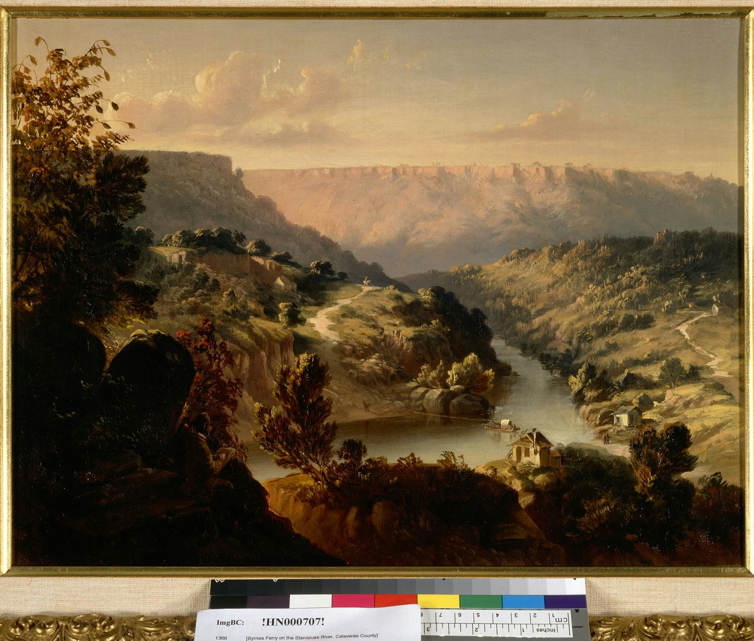
Gorham Ranch. One of the earliest ranches in the area was that of the Gorham brothers, established in the Stanislaus River Canyon north of the O’Byrnes Ferry crossing in the 1850s. William Gorham, known as “Billy By God” for his constant use of the expression, and his wife Lucinda were the first Gorhams to come to the area. The original homestead (depicted in a painting of O’Byrnes Ferry by painter Thomas Hill) was washed away in the flood of 1862. The family then moved their farm complex to a site on the west side of O’Byrnes Ferry Road, about two miles north of the ferry crossing (SW ¼ of Section 19, T1N, R13E). John Nelson Gorham and Marietta Martin Gorham settled on Lux (Loucks) Creek, east of William’s landholdings, in 1873. Their daughter Lillian described the ranch thusly:
"The Gorham Ranch was really a community sufficient unto itself. Not far distant was the ranch home of Uncle William Wallace Gorham and his wife, Lucinda and their nine children. The school at O’Byrnes Ferry flourished as long as these two families supplied the pupils" (Lillian Gorham Murphy, in Stone 1991:88).
The senior Gorhams moved to Farmington in 1890, where their descendants reside today.
Although the Gorham, Spicer, and Moulton ranches were the largest and longest established ranches on the Calaveras side of the river, several other parcels of land were patented in the 1880s and 1890s (Calaveras County Land Patent Maps; Skidmore Patent Maps). Little is known of their histories, but as some of the lands wound up in large landholdings, it is probable that many of the patentees simply resided on the land long enough to obtain title and then sold to adjoining land owners or employers.
Tuolumne County Ranches. The first patents of record on the Tuolumne side of the Stanislaus River were those of the Laughlin family, who established a ranch on the Central Ferry Road. John and Martha Laughlin filed patents to several hundred acres of land in the 1870s (Sections 15 and 22, T1N, R13E), while William Laughlin patented land in the SW ¼ of Section 22 in 1899, near the Currie Cement Mine (Calaveras County Land Patent Maps). By 1904 William Laughlin was in partnership with the McCormick Company on the senior Laughlins’ property (Thom 1907).
By the early 1900s, the two largest landholdings on the Tuolumne side of the Stanislaus River in the area were those of the M. McCormick Company and the M.J. Wolfling Company, both cattlemen and butchers. Critical as a supporting service, stock raising quickly became one of the most important industries of the counties in the early years. Stockmen took up large landholdings in the foothills, driving their herds of cattle, sheep, and hogs to the high country every summer to graze the mountain meadows and grasslands
M. McCormick Company. The company established extensive cattle and butchering interests in Tuolumne and San Joaquin counties, with a butcher shop in Sonora operated by Frank McCormick. By the turn of the nineteenth century, James McCormick, treasurer of the City of Sonora, was the owner of vast tracts of land, both in the mountains and foothills, where large herds of cattle were pastured (Progressive Association 1901:85). Andrew McCormick was president of the M. McCormick operations in the early 1910s, which included an immense establishment in Stockton (Union Democrat 1909:107). The company owned large acreages on Peoria Flat, on both sides of the O’Byrnes Ferry Road, as well as along the Stanislaus River (Thom 1907).
M.J. Wolfling Company. John Wolfling established a meat market business in Sonora around 1860, which was inherited by his son Michael J. Wolfling. By 1900 the company operated a large and extensive cattle raising and retail butcher business, being one of the largest landholders, with ranches in various parts of Tuolumne County (Progressive Association 1901:84). The Wolfling Company owned several sections of land in the area, southeast of the Stanislaus River, near O’Byrnes Ferry (Thom 1907).
Schools. Two schools served the children of the area, on both sides of the river. The O’Byrnes Ferry School, on the Calaveras side of the river, was located midway between Copperopolis and O’Byrnes Ferry, on the Mark McCormick Ranch on the O’Byrnes Ferry Road. It was established in 1875 when there were enough children from nearby ranches to justify a school. The district was organized from part of the Copperopolis District and was in session for 46 years, closing in 1921 (Calaveras County Historical Society 1986:69).
In Tuolumne County, the Green Springs School District, which served the children from the Tuolumne side of the area, encompassed an area that commenced at Stanislaus County in the south, ran up the east side of the Stanislaus River to O’Byrnes Ferry, and thence up Green Spring Run to New York Tent Gulch (Chispa, Vol 26, No. 3:887).
Names of Selected Locations
Black Creek. Named for the ranch of John and Peter Black, noted as a valuable farm in 1858 (San Andreas Independent, April 19, 1858). It was located on Black Creek, near present Copperopolis.
Four Springs Run. Named for the Four Springs Ranch, one of the earliest to be settled near the area that later became Copperopolis. Established sometime prior to 1851 by Solomon White, it was located on Sawmill Creek, near the junction of the Stockton Road (present Highway 4) and Reed’s Turnpike. By 1858 it was owned by Messrs. Reynolds & Co., and noted as being located on the Reynolds Road (present Highway 4) (Calaveras County Assessment Rolls 1858-1859).
Loucks/Lux Creek. Named for an early settler in the area (Charles Stone, personal communication)..
Negro Jack Gulch/Peak. Jack Wade, better known as “Nigger Jack,” arrived in California as a slave. He bought his freedom, and settled a 460-acre ranch at the base of Table Mountain, southwest of the O’Byrnes Ferry Bridge. A recluse, Jack lived alone to an old age in a tiny hut exactly in the middle of his property, surrounded by his cattle, hogs, and chickens (Stone 1991:59).
References Cited or Consulted
Beauvais, A.B.
1882 Map of the County of Tuolumne. Tuolumne County Recorder’s Office, Sonora, California.
Bishop, Frances
n.d. Stanislaus River Ferries. Notes on file, Calaveras County Archives, San Andreas, California.
Borthwick, J.D. (index and foreword by Joseph A. Sullivan)
1857 3 Years in California. Reprinted by Biobooks, Oakland.
Brotherton, I.N. “Jack”
1982 Annals of Stanislaus County. Volume I, River Towns and Ferries. Western Tanager Press, Santa Cruz.
Calaveras, County of
Land Claim Books
Homestead Books
Deed Books
Mining Claim Books
Water Right Books
Assessment Rolls
Great Register of Voters Lists
Vital Statistics
Probate Records
Articles of Association
Mechanics Lien Books
Books of Agreements
Minutes of the Court of Sessions
Calaveras Chronicle
var. Calaveras Chronicle, San Andreas. On file, Calaveras County Archives, San Andreas, California.
Calaveras County Historical Society
1986 An Album of the Pioneer Schools of Calaveras County. Calaveras County Historical Society, San Andreas, California.
Chispa
var. The Quarterly Bulletin of the Tuolumne County Historical Society, Sonora, California.
Clark, William B., and Philip A. Lydon
1962 Mine and Mineral Resources of Calaveras County, California. California Division of Mines and Geology County Report Number 2. California Division of Mines and Geology, San Francisco.
Columbia Gazette
var. Columbia Gazette, various issues.
Cunningham (Marvin), Judith
1988 Historical Report on the Spicer Ranch and Rancho del Rio Estanislao for the Proposed Copper Cove Effluent Disposal Pond. Prepared for Davis-King & Associates, Standard, California, for submittal to Calaveras County Water District, San Andreas, California.
Davis-King, Shelly, and Judith Marvin
1990 Black Creek Estates and Golf Resort Cultural Resources Reconnaissance. Submitted to Mother Lode Engineering, Altaville, California.
1994 Contextual History of Tuolumne County. Davis-King & Associates, Standard, California and Foothill Resources, Ltd., Murphys, California. Prepared for The County of Tuolumne, Sonora, California.
De Ferrari, Carlo M.
1999 Personal communication of 25 January 1999. Notes on file, Foothill Resources, Ltd., Murphys, California.
Divoll, J.G.
1882 A History of Tuolumne County, California. B.F. Alley, San Francisco. Republished by the Tuolumne County Historical Society, Sonora, California, 1983.
Elliott, W.W.
1885 Calaveras County Illustrated and Described. W. W. Elliott, Oakland, California. Republished by the Calaveras County Historical Society, Valley Publishers, Fresno, 1976.
Farquhar, Francis P.
1930 Up and Down California in 1860-1864, The Journal of William H. Brewer. Yale University Press, New Haven, Connecticut.
Fuller, Willard P., Jr., Judith Marvin, and Julia G. Costello
1996 Madam Felix’s Gold, The Story of the Madam Felix Mining District, Calaveras County, California. Calaveras County Historical Society and Foothill Resources, Ltd., Calaveras County.
Greeley, O.F., Secretary
1901 Illustrated Historical Brochure of Tuolumne County, California. Compiled and Issued by The Progressive Association, Sonora, Tuolumne County, California. Republished by the Tuolumne County Historical Society, Sonora, California, 1999.
Lewis, L. Helen
1968 A History of Copperopolis. Calaveras County Office of Education, San Andreas.
Gudde, E.G.
1969 California Place Names, 3d ed. University of California Press, Berkeley.
1975. California Gold Camps. Edited by E.K. Gudde. University of California Press, Berkeley.
Heckendorn & Wilson
1856 Miners & Business Men’s Directory. Columbia, California. Republished by the Donald I. Segerstrom Memorial Fund, Sonora, California, 1976.
Herbert, Rand F., and R. Meta Bunse
1993 Historic Resource Evaluation Report for the SR-120 Oakdale Bypass Interchange Improvement Project Alternatives 1, 2A, 2B, 2C, and 2D. Postmile: 3.0/14.1, Contract: 10B933, EA: 10-345400. Prepared for Caltrans District 10, Stockton, California, by JRP Historical Consulting Services, Davis, California.
Lang, H.O.
1882 History of Tuolumne County, California. B.F. Alley & Co., San Francisco.
Las Calaveras
var. The Quarterly Bulletin of the Calaveras County Historical Society, San Andreas, California.
Lewis Publishing Company
1892 A Memorial and Biographical History of the Counties of Merced, Stanislaus, Calaveras, Tuolumne and Mariposa, California. The Lewis Publishing Company, Chicago. Facsimile Reproduction published by the McHenry Museum of Art and History, Modesto, California, 1980.
Mace, O’Henry
1991 Between the Rivers, A History of Early Calaveras County. Gold Country Enterprises, Sutter Creek, California, and Cenotto Publications, Jackson, California.
Marvin, Judith
1992 Preliminary Historical Investigations of the Flowers Ranch, Near Copperopolis, Calaveras County, California. Prepared for Archaeological Services, Inc., Stockton, California.
1994 Preliminary Historical Investigations for Three Historic Sites on the Proposed Woodside Partners Project, Near Copperopolis, Calaveras County, California. Prepared for Archaeological Services, Inc., Stockton, California.
1995 Historical Investigations for Three Historic Sites on the Proposed Calaveras Country Club Project Near Copperopolis, Calaveras County, California. Prepared by Foothill Resources, Ltd. for Archaeological Services, Inc., Stockton, California.
Perkins, William (introduction and annotation by Dale L. Morgan & James R. Scobie)
1964. Three Years in California, William Perkins Journal of Life at Sonora, 1849-1852. University of California Press, Berkeley.
Progressive Association of Sonora (O.F. Greeley, Secretary)
1901 Illustrated Historical Brochure of Tuolumne County California. The Progressive Association, Sonora, Tuolumne County, California. Republished by the Tuolumne County Historical Society, 1999.
Ruppel, Margaret Gaylord
1946 El Rancheria del Rio Estanislao, A History. Castle Press, Pasadena, California.
San Andreas Independent
Various issues.
Stewart, Suzanne B.
1991 A Cultural Resources Study for the Bank of San Francisco Copperopolis Project, Calaveras County, California. Prepared for the Bank of San Francisco and Woodside Partners, Archaeological Services, Inc., Stockton, California.
Stoddart, R.R. (Edited and Annotated by Carlo De Ferrari)
1963 Annals of Tuolumne County. Valley Publishers, Fresno, California.
Stone, Rhoda and Charles A.
1991 The Tools are on the Bar. The History of Copperopolis, Calaveras County, California. Rhoda and Charles Stone, Copperopolis, California.
Tinkham, George H.
1921 History of Stanislaus County. History Record Company, Los Angeles.
Tuolumne, County of
Land Claim Books
Homestead Books
Deed Books
Mining Claim Books
Water Right Books
Assessment Rolls
Great Register of Voters Lists
Vital Statistics
Probate Records
Maps
Union Democrat
1909 Tuolumne County California. The Union Democrat, Sonora, California. Republished by the Tuolumne County Historical Society, Sonora, California, 1995.
United States Federal Census
1860 Population Schedule. Calaveras County. Microfilm.
1870 Population Schedule. Calaveras County. Microfilm.
1880 Population Schedule. Calaveras County. Microfilm.
1900 Population Schedule. Calaveras County. Microfilm.
Wood, Richard Coke
1955 Calaveras, The Land of Skulls (Calaveras County). The Mother Lode Press, Sonora, California.
Interviews
Hiatt, Ella McCarty
1991 Notes on Interview of 1991. On file, Foothill Resources, Ltd., Murphys, California.
Stone, Charles
1994 Notes on interview of 28 December 1994. On file, Foothill Resources, Ltd., Murphys, California.
1995 Notes on interview of 12 April 1995. On file, Foothill Resources, Ltd., Murphys, California.
Maps
Agostini, J.J.
1904 Official Map of Calaveras County, California. J.J. Agostini, San Andreas, California.
Barton, Eugene H.
1896 Map of the Mother Lode and Principal Quartz Mines in the Counties of Tuolumne and Calaveras. Sonora, California.
Calaveras County Land Patent Maps
n.d. On file, Calaveras County Surveyor’s Office, San Andreas, and Foothill Resources, Ltd., Murphys, California.
Dart, J.P.
1879 Map of the Principal Quartz and Gravel Mines in Tuolumne County, California. A. L. Bancroft & Co., Lithographers, San Francisco.
General Land Office
1870 Township 1 North, Range 12 East Plat Map
1869 Township 1 North, Range 13 East Plat Map
1870 Township 1 South, Range 12 East Plat Map
18xX Township 1 South, Range 13 East Plat Map
Handy & Wallace
1864 Map of the Copper Mines of Calaveras County. A. Gensoul, San Francisco. On file, Bancroft Library, University of California, Berkeley.
Pilkington, Thomas
1854? Map of Calaveras County. On file, Bancroft Library, University of California, Berkeley.
Skidmore, C.E.
Var. Land patent maps on file, Tuolumne County Recorder, Sonora, California.
Thom, Robert
1907 Official Map of Tuolumne County. Sonora Abstract and Title Company, Sonora, California. On file, Tuolumne County Surveyor’s Office, Sonora, California.
United States Geological Survey
1916 Copperopolis Quadrangle. Scale 1:625,000. Surveyed 1914.